A land application setback distance is the minimum distance required between manure application areas and sensitive areas that may be vulnerable to water pollution. The purpose of a setback is to reduce the potential for contaminants to reach ground or surface water. Properly managed setbacks improve water quality by acting as filters for water passing over or through the soil toward a water resource.
Sensitive areas and their required setback distances vary from state to state. Missouri recommendations and requirements are listed in Table 1.
Table 1
Recommended separation distances for land application of biosolids.
| Type of sensitive setback area | Separation distance |
|---|---|
| Wells, abandoned wells, sinkholes, caves and losing streams* | 300 feet |
| Permanently flowing and intermittent streams | 100 feet |
| Privately owned impoundment (ponds) not used as a water supply* | 100 feet |
| Property lines* | 50 feet |
| Neighboring houses or public use areas* | 150 feet |
*Required by Missouri regulations (Department of Natural Resources, Clean Water Commission, Chapter 8, Design Guide (10 CSR 20-8.020)).
What do I need to do?
Figure 1 is an aerial map identifying some common sensitive areas on a farm. In preparing information for your nutrient management plan you should use a map like this that clearly represents the area receiving manure. Use a marker on the map to locate and clearly label known or possible sensitive areas in or near fields where you apply manure.
From the map you prepared (Figure 1), your planner will develop a map similar to Figure 2 detailing the sensitive areas and the required setback distances for manure application. Manure application is not permitted in areas shown in red in Figure 2.
You should provide a map of land application setbacks to anyone spreading manure on your farm so they know the areas that can and cannot receive manure.
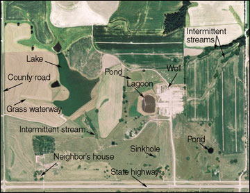 Figure 1
Common areas vulnerable to water pollution on a farm.
Managing setback areas
Manure application is not allowed in setback areas. Setback areas can still be used for crop production. There also are no limits on the use of fertilizer materials other than manure and biosolids in the setback area.
The most effective conservation practice in setback areas for protecting water quality is a permanently vegetated filter strip. Consider removing setback areas from crop production and planting them to a mixture of grass and woody species. These species will maximize the ability of the setback to filter out nutrients and eroded soil moving toward the sensitive area. Work with your local office of the Natural Resources Conservation Service to plan vegetated filter strips.
Fertilizer applications to setback areas require special care because of their proximity to a water resource. Some fertilization will be needed on many setbacks to ensure dense, high-quality soil cover. When using fertilizer on setback areas:
- Carefully time any fertilizer applications to minimize the possibility of a runoff event soon after application.
- Do not overapply fertilizers to setback areas and apply mobile nutrients such as nitrogen during the active growing season to further limit losses.
- Remember, no manure or biosolids applications are allowed on the setback area — only commercial fertilizers.
Other considerations
Setbacks to streams also apply to any type of man-made structure that directs water to a stream or lake. For example, risers in a terraced field require a setback unless they are plugged during manure application. The centerline of a grassed waterway also requires an intermittent stream setback.
Missouri setbacks currently do not account for local topography. The setback requirement does not decrease if the slope in one direction falls way from a setback feature. For example, a riser in a terraced field has a circular setback even if the setback area extends over the up- or down-slope terrace.
Areas with expected flood frequencies of greater than once in ten years should also be noted and should not be the only land available for application of manure.
Setback distances can reduce the number of acres available for manure application depending on the proximity of the sensitive areas to fields on your farm. Figure 3 is a map developed using the MU Spatial Nutrient Management Planner (SNMP). This map includes an aerial map of the farm, delineation of field boundaries (yellow lines), in addition to the setback areas (shown in red). Each field is labeled with the field name (top label), field size (second label) and acres suitable for manure application (third label). For example, in Field 11 on the south side of the farm in Figure 3, field size is 76.4 acres but setbacks for a residence, road, stream and sinkhole result in 61.1 acres suitable for manure application; 15.3 acres of the field are off limits for manure application.
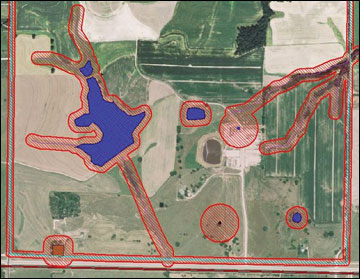 Figure 2
Aerial photograph of a farm with setbacks around sensitive areas shown in red.
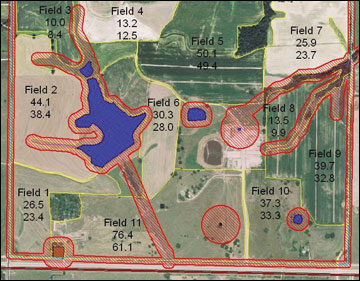 Figure 3
Map of a farm generated by the software program Spatial Nutrient Management Planner (SNMP).
The setbacks in Table 1 and shown in Figures 2 and 3 are state recommendations and requirements. Some counties and townships in Missouri have more stringent requirements. Find your farm on the animal feeding operation site evaluation website at http://cares.missouri.edu/afosite/ to see if you are affected by local limits on land application of manure.